This 3-week mission that will take us (after sailing some 1,500 nautical miles) from the Glorious Islands to Juan de Nova through the continental shelf off Majunga promises to be dense and rich with loaded targets.
On the program: bathymetric and sonar data acquisition, seismic data acquisition and sediment grab sampling.
The main objective of this new REEFCORES mission is to reconstruct sea level variations and environmental and climatic changes from Quaternary to the present day.
For this, Antsiva is equipped with a new equipment for the installation of a multibeam echosounder: it is a swivel pole with a length of 3.50m, fixed to the front of the boat. This boom can accommodate a sounder but also many other instruments oceanographers.
Antsiva, calling at Reunion has already loaded in its bunkers the 8 pallets of equipment that scientists will need during this mission. For navigation to Madagascar all crates have been rigged and stowed but even tidy they already represent a volume of nearly 10m3.
D-Day, Antsiva embarks the whole team to Diégo Suarez. Hardly on board, geologists are eager to test and install their equipment. In a few hours, all the boxes are emptied, their contents unpacked and the ANTSIVA volumes transformed into different scientific laboratories.
Thus, the front cabin becomes the "bathymetry lab": screens, computers, transmitters, receivers and processing units are quickly mounted and fixed on the table, electric cables run forward. back of the boat.
Christophe is the conductor of this transformation and, in spite of the suffocating heat, our geologists, in swimming constantly pursue the installation of the other instruments. They then install the "seismic lab" in the main hold. Here again screens and processing units are strapped, and still these electric cables which, such capricious creepers arise and gradually invade the airspace of the boat.
Finally, several GPS antennas are deployed and an additional screen is attached to the cockpit. The latter will prove very useful since it will allow the pilot to follow the cartography of the bathymetry live and stay in the fixed lines.
There remains one last thing to do before the apparatus (and not least): the test of the multibeam sounder and its installation on the pole. The sonar is then fixed and bolted to the plate at the end of the pole. This one slides in a sleeve and goes down until the apparatus is found at 1.5m under water. After some unsuccessful attempts, Charline leaves the cabin with a smile "It works, it's great! "
And now, the cry of departure is launched. Everything is ready, we can weigh anchor. We leave the port of Diégo to the tide slack not to suffer too much the phenomena of current against wind frequent in the pass.
Until the Cap d'Ambre, it shakes a lot and the first hours of navigation are not very comfortable but it allows the whole team to glide quickly. Around midnight, we pass the famous Northern Cape of Madagascar. As if by magic, the sea is leveling, the wind is favorable to us. We hoist the sails to let ourselves grow to the Glorious.
The Glorious and the Isle of Lys
Wake up early in the mornings Glorious. Everyone is on the bridge, eager to find or discover this green island on its turquoise lagoon.
But the scientists' time is running out and it's about optimizing this first day of work.
The formalities carried out, we disembark the team of turtles on land with an annex and fuel and let Mayeul and Claire to the good load of the soldiers who, very nicely, will offer them the cottage and the cover during the 4 days they will go on Glorious.
Their work will consist of immature catches on which they will carry out the following operations: baggage, weight and measurement, profile and scale photo and genetic sampling.
And we leave with the team of geologists to immediately start the data acquisition and make a first profile and a first small "box" on the island of Lys.
We will stay there for the duration of the Glorious, since the work of geologists is located on this part of the island.
Once the instruments are deployed, ie the multibeam echosounder and the seismic cables launched, the work on board Antsiva consists of following lines given by Gwen. The work of the pilot requires a great concentration because the boat must not deviate from these lines.
As we progress, we see the seabed in live and in color on the screen the bathymetry installed at the chart table.
A "box" is made when enough profiles have been made on a given area.
Meanwhile, Christophe and Pascal, each "isolated" respectively in the forward cabin and in the cargo hold manage and monitor their instruments. Charline, meanwhile, staring at her computer screen processes data acquired the day before.
For two days in a row, Stéphane and Simon descend to the ground to study the rocks and the particular geology of the ancient submerged reefs of the island of Lys. So we leave them in the morning on this island where the vegetation is rare and the sun relentless and we find them in the evening somewhat leached but very enthusiastic.
The 3rd evening, we return to the anchorage of Glorieuses to find Mayeul and Claire who are in lack of fuel for the annex. They suggest geologists to follow them during their night campaign. The interest of these multidisciplinary missions also lies in these exchanges between scientists and this is an opportunity for geologists to participate in a "turtle nesting" evening on the beach in the company of turtle specialists who will guide them and give them all the necessary explanations.
Four days to Glorious, all the profiles have been realized. It is time to go back to sea because two days of sailing are necessary to reach the port of Majunga. As no seismic or bathymetry work is planned on the route, we take the opportunity to fish along the Malagasy coast.
On arrival in Majunga, Stéphane and Jérôme are already waiting for us to change the "turtle" duo.
The time of a supply of fruits and vegetables and here we are headed towards Juan de Nova. This trip will still take us 2 whole days because many profiles and different "boxes" must be made during this crossing. The work is chained night and day and shift teams take turns for steering and monitoring instruments.
Juan de Nova
Finally, on the 5th of April we reach the anchorage of Juan de Nova. Jerome and Stéphane are on the starting blocks and arrive immediately. They are eager to experiment on the ground with their new manipulation. This is to pose on the shell of some juvenile turtles a Go pro camera that will record all their movements. The goal is to discover the feeding places of these turtles.
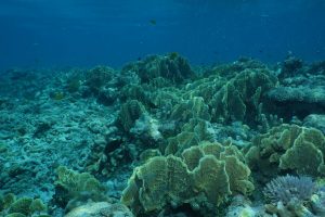
Two geologists, Stéphane and Simon also descend ashore to study the formerly submerged coral reefs of Juan de Nova.
The southern part of the island presents particularly interesting formations with vast excavations in the coral and enomes fossil clams.
Meanwhile, the work of geologists repends.
The seismic and bathymetry devices are deployed again. Alex also installs a small sonar that we hang in the back of the boat.
And while Antsiva conscientiously follows the lines of the profiles given by Gwenael, the appendix leaves with a small team to take samples of sediments by bucket.
The four days spent on Juan de Nova will allow us to sail up and down the entire lagoon. And after some 150 nautical miles of profiles done on this lagoon, this one will really have no more secrets for us!
For the last morning, all scientists arrive on the island. It is a question of recovering the material left on the ground by the team of geologists. It is also an opportunity for them to stretch their legs and take a dip in the wonderfully turquoise waters of Juan de Nova.
At 3 pm, the white "tuttle men" annex comes back on board. We are waiting for them to weigh anchor and leave Juan de Nova for Mayotte.
This time, Eole is not with us; the south wind that had been blowing for two days has weakened and it is all the engine that we will make this last crossing.
But that leaves time, time ...
geologists to unplug all the instruments and calmly store the material in the many trunks provided for this purpose.
Charline to finish the data processing and finally be able to see serenely a sunset
Stéphane and Jérôme watch the movie hours where turtles swim, swim and swim ...
Simon to present us very pedagogically his thesis project
Christophe to try an nth approach to pussy Cinnamon
Gwen to recover a few hours of sleep rocked in the hammock
and for all to enjoy a brief parenthesis away from any outside aggression
Thank you to the entire team for this new mission which remains an adventure in its own right.
Thanks to Ifremer Brest and IUEM who have allowed ANTISVA to acquire new skills and new tools in the field of bathymetry,
Thanks to Ifremer Reunion and Jérôme for the logistical and moral support provided during the development of this mission
Thanks to Kélonia for its teams of 'turttle men', always so professional
And finally thank you to Gwenael and Stephane who, despite the many difficulties encountered during the assembly of this mission we have always trusted.